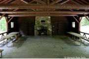
Allis State Park, VT
Book a Campsite at Allis State Park, VT
** Same-day reservations must be made by calling the park directly.
*** Some sites may be available only from the campground on a first-come-first-served basis.
Description
This park was established in 1928 as Vermont's second developed state park. The park is named for Wallace Allis, who willed his Bear Mountain Farm to the State of Vermont to be developed as a campground and recreational area. The park was developed by the CCC and offers tent, RV and lean-to camping, a log picnic pavilion, trails and a firetower that provides sweeping views of surrounding of central Vermont's mountains and valleys. This park is located just off one of Vermont's last remaining gravel state highways and is perfect for those looking for a quiet camping experience.
Geography:
The park is located on the summit of Bear Hill which provides sweeping views of central Vermont from a lookout tower once used to spot forest fires. On a clear day, Killington, Pico, and Mt Ascutney peaks are visible to the south; Camel's Hump and Mt. Mansfield to the north; Abraham, Lincoln, and Ellen to the west; the White Mountains of New Hampshire to the east. The fire tower has an information panel explaining the view.
Recreation:
This quiet park provides excellent camping and hiking and excellent bass fishing is located nearby.
Facilities:
18 tent/RV sites, 8 lean-tos, a group camping area, a restroom with flush toilets, hot and cold running water and coin-operated showers. A day use area on the hilltop includes a large log picnic pavilion capable of holding groups as large as 100 people. Accessible restrooms are available at the pavilion. Drinking water is available throughout the park. In addition, there is a picnic area and a lookout tower. There is an RV sanitary station but there are no hookups. No camping in or around pavilions. Camping on designated campsites only.
Booking Rules
Reservations must be made 1 Day(s) ahead of arrival.New dates are released in blocks, 1 Month(s) at a time.
Season Schedule
- Accessible
- Accessible Campsites
- Accessible Flush Toilets
- Accessible Pavilion
- Accessible Picnic Areas
- Campfire Rings
- Campsites, Tent/RV
- Coin Showers
- Day Use Area
- Dump Station
- Firewood
- Fishing Licenses
- Flush Toilets
- Grills
- Group Camping
- Horseshoe Pit
- Lean-tos
- Lookout Tower
- Park Office
- Pavilion
- Pets Allowed
- Picnic Area
- Recycling
- Tables
- Trails, Hiking
- Trails, Interpretive
- Trash Disposal
- Water Spigot
Fees and Cancellation
For information on Fees, please click here.
44.05168, -72.63158
44°3'6"N, 72°37'54"W
From South (Montpelier): Take I-89 to Exit 4; Turn left onto VT 66 West and travel for 1.6 mi; turn right onto Windover Rd. and travel for .4 mi.; continue straight onto VT 12 North for 10 mi.; turn right onto VT 65 East (a gravel road) and for 1.3 mi.; turn right onto Allis State Park Rd. up the hill and continue .5 mi. to park headquarters. From North (Burlington): Take I-89 to Exit 5; turn right onto VT 64 West and continue for 2.7 mi.; turn left onto VT 12 South for 4.4 mi.; turn left onto VT 65 East (gravel road) for 1.3 mi.; turn right onto Allis State Park Rd. up the hill and continue .5 mi. to park headquarters.
Park Address: 284 Allis State Park Rd., Randolph, VT 05060


/-72.6315833,44.0516833,8,0/280x280?access_token=pk.eyJ1IjoiYXNwaXJhLW1hcHMiLCJhIjoiY2tlYmxiaWt3MDMwcTJ5cDN5bGwzZTUwNCJ9.IK2OEvl3EWmVLXYD9Rnedw)


